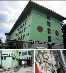
The M6.9 earthquake hit Sikkim on 18th September 2011 at 6:11 PM IST with its epicenter located at 27.72°N, 88.06°E, near Nepal-Sikkim border, about 68 km NW of Gangtok and at a focal depth of 19.7 km. It was a shallow focus event, which was felt in India, Nepal, Bhutan, Bangladesh and Tibet. Three aftershocks of magnitude 5.7, 5.1 and 4.6 were also felt in Sikkim within 30 minutes of the earthquake. About 100 deaths are reported in India with the maximum of at least 60 in the state of Sikkim. The earthquake caused widespread damage and destruction in Sikkim with the maximum intensity of VIII at Chungthang and Lachung, VI in and around Gangtok and Mangan on MSK scale. Sikkim lies in the second highest seismic zone (i.e., zone IV) of Indian seismic code IS: 1893 with the expected intensity of VIII in MSK scale. Non-existent earthquake resistant construction led to unacceptable level of damage to a large number of RC buildings and some dramatic collapses even when the intensity of shaking was less than that expected in a design level earthquake which indicates their high seismic vulnerability. Consequently, the seismic risk in the region is growing at an alarming pace with increasing inventory of seismically deficient constructions. |
 |